Contact | RSS | EN | DE | EL | ES | FR | IT | RU

Laguna del Maule Volcano

Updated: May 13, 2024 17:23 GMT -
caldera 3092 m / 10,144 ft
Central Chile, -36.02°S / -70.58°W
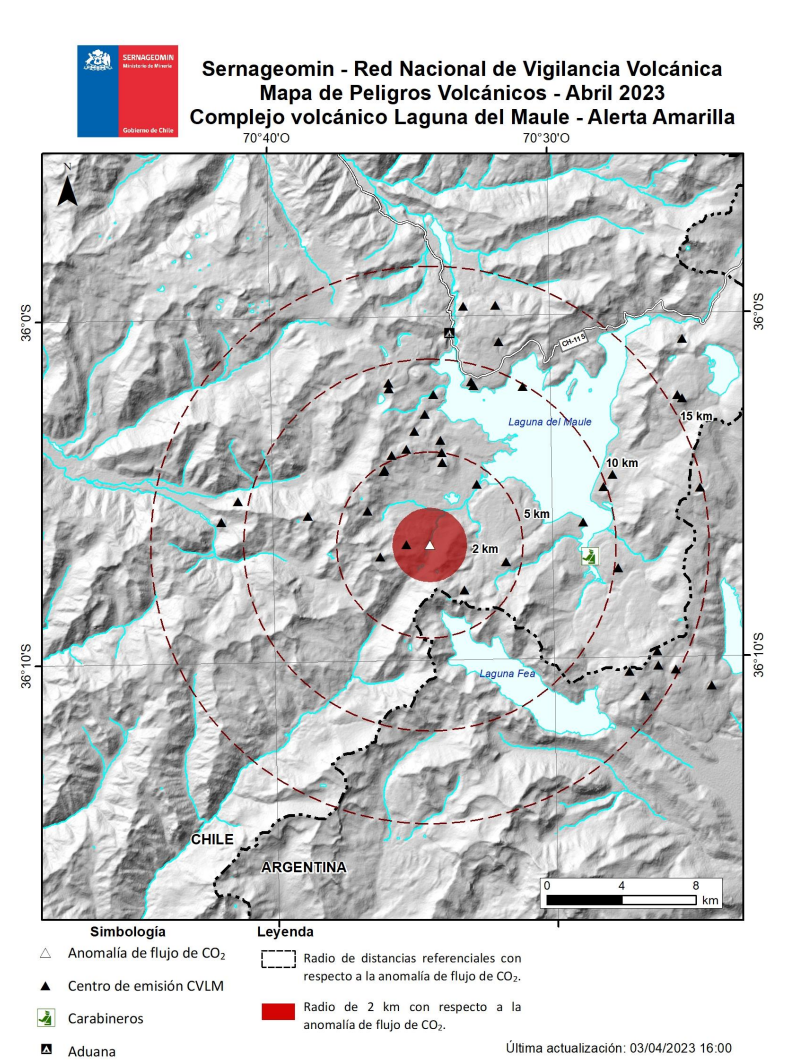
Current status: restless (2 out of 5)
Last update: 13 Oct 2023 (Smithsonian / USGS Weekly Volcanic Activity Report)

Laguna del Maule is a 15x25 km wide lake-filled volcanic caldera in central Chile near the border to Argentina, east of Nevados de Longavi volcano. The complex is less than 30,000 years old and covers 300 km2 contains a cluster of small stratovolcanoes, lava domes, and cinder cones some of which are younger than 10,000 years.

[smaller] [larger]
Typical eruption style: explosive
Laguna del Maule volcano eruptions: unknown, but less than 10,000 years ago

Latest nearby earthquakes

No recent earthquakes
TimeMag. / DepthDistance / Location

Background

In this region of the Andes, the volcanoes are about 90 km above the top of the subducting slab of the Nazca place, the so-called Benioff zone, which dips at an angle of 25 degrees. The subducting plate is broken into different segments subducting at different angles under continental crust of varying thickness. This results in zones of different magma generation. Volcanoes around 33-34 deg S are predominantly andesitic, while volcanoes south of 37 deg S are more basaltic. The Laguna del Maule volcano lies in this transition zone. It has more silica-rich, even rhyolite lavas than the volcanoes further to the south, which are mainly basaltic.

4 volcanic units are distinguished in the evoution of the Laguna del Maule volcanic complex:
1) Valley unit
2) Dikes and Volcanic neck unit
3) Volcanic Cones
4) Lake unit

Valley unit: 14 lava flows are found exposed in the upper part of the Maule river valley. Their vents are covered by younger lava flows of the Lake unit.
The Lake unit consists of rhyolitic domes and flows, as well a cluster of Pleistocene cones found around Maule Lake. The individual vents include Domo del Maule, Loma de los Espejos, Colada Occidental, Colada Dendrifonne, Colada las Nieblas, Cerro Barrancas, Colada Cari-Launa, and an explosion crater on the eastern side of the lake. The latter represents the latest activity from Laguna del Maule.
---
Source:
- Frederick A. Frey, David C. Gerlach, Rosemary L. Hickey, Leopoldo Lopez-Escobar and Francisco Munizaga-Villavicencio (1984) "Petrogenesis of the Laguna del Maule volcanic complex, Chile (36° S)", Contributions to Mineralogy and Petrology, Volume 88, Numbers 1-2, 133-149

Latest satellite images

maule satellite image sat1maule satellite image sat2
Wed, 5 Apr 2023, 14:00

Laguna del Maule volcano (Central Chile-Argentina) - Smithsonian / USGS Weekly Volcanic Activity Report for 29 March-4 April 2023 (New Activity / Unrest)

SERNAGEOMIN reported that increased seismicity at Laguna del Maule was first registered around 1800 on 30 March. The seismic monitoring stations recorded a swarm of 300 volcano-tectonic earthquakes that occurred in an elongated area in a NW-SE direction approximately 10 km SW of the crater at a depth of up 8 km. These events were associated with rock fracturing processes. ... Read all
Tue, 4 Apr 2023, 14:06

Laguna del Maule (Central Chile): Alert level raised, volcanic complex in yellow alert

Updated hazard map for Laguna del Maule. Source: SERNAGEOMIN
Yesterday afternoon, SENAPRED (Chilean disaster prevention and response service) and SERNAGEOMIN (Chilean geology and mining service) announced an increase in the alert level at Laguna del Maule from green to yellow (the second lowest of a four colour scale). ... Read all

On this page:

Try our free app!
Volcanoes & Earthquakes - new app for Android
Android | iOS version

More on VolcanoDiscovery

Why is there advertising on this site?

Support us - Help us upgrade our services!

We truly love working to bring you the latest volcano and earthquake data from around the world. Maintaining our website and our free apps does require, however, considerable time and resources.
We need financing to increase hard- and software capacity as well as support our editor team. We're aiming to achieve uninterrupted service wherever an earthquake or volcano eruption unfolds, and your donations can make it happen! Every donation will be highly appreciated. If you find the information useful and would like to support our team in integrating further features, write great content, and in upgrading our soft- and hardware, please make a donation (PayPal or Online credit card payment).

Planned features:Thanks to your past donations, these features have been added recently:
Download and Upgrade the Volcanoes & Earthquakes app to get one of the fastest seismic and volcano alerts online:
Android | IOS
Thank you!
Sources: VolcanoDiscovery / VolcanoAdventures and other sources as noted.
Use of material: Most text and images on our websites are owned by us. Re-use is generally not permitted without authorization. Contact us for licensing rights.
Volcanoes & Earthquakes
VolcanoDiscovery Home
Volcanoes | Earthquakes | Photos | Volcano News | App
Adventure & Study Travel
Tours to Volcanoes and Volcanic Areas: walking tours, photo tours, study tours
Tours & Dates | FAQ | About us
Get our newsletter!
Company info
Contact | Legal info | Terms & conditions
Follow us
Follow us on facebook Follow us on Instagram Follow us on Twitter Visit our Youtube channel
EN | DE | EL | ES | FR | IT | RU
VolcanoDiscovery GmbH, Germany, Reg. nr.: HRB 103744, EU Tax Id: DE 297 465 123 owned and created by
Dr. Tom Pfeiffer, volcanologist, volcano photographer, tour organizer member of
IAVCEI
IAVCEI
Vulkanologische Gesellschaft
Volcanological Society
Ecotourism Greece
Ecotourism Greece
RUV insurance
Insured by R+V
VolcanoDiscovery © 2004- All Rights Reserved | Privacy - Cookie Settings