Contact | RSS | EN | DE | EL | ES | FR | IT | RU

Mag. 3.2 earthquake - Albania on Sunday, Jan 14, 2024, at 12:23 am (Tirane time) -

A light magnitude 3.2 earthquake hit 7.8 km (4.9 mi) away from Lushnje, Qarku i Fierit,  Albania, in the early morning of Sunday, Jan 14, 2024 at 12.23 am local time (Europe/Tirane GMT +1). The quake had a very shallow depth of 5 km (3.1 mi) and was felt widely in the area.

Mag. 3.2 earthquake - Albania on Sunday, Jan 14, 2024, at 12:23 am (Tirane time) Mag. 3.2 earthquake - Albania on Sunday, Jan 14, 2024, at 12:23 am (Tirane time)
Light magnitude 3.2 earthquake at 5 km depth
13 Jan 23:28 UTC: First to report: SSS after 5 minutes.
Update Sat, 13 Jan 2024, 23:39

Magnitude 3.2 earthquake strikes near Lushnje, Rrethi i Lushnjës, Qarku i Fierit, Albania

3.2 quake 14 Jan 12:23 am (GMT +1)
The Seismological Survey of Serbia (SSS) reported a magnitude 3.2 quake in Albania near Lushnje, Rrethi i Lushnjës, Qarku i Fierit, only 16 minutes ago. The earthquake hit after midnight on Sunday, January 14th, 2024, at 12:23 am local time at a very shallow depth of 5 km. The exact magnitude, epicenter, and depth of the quake might be revised within the next few hours or minutes as seismologists review data and refine their calculations, or as other agencies issue their report.
Based on the preliminary seismic data, the quake should not have caused any significant damage, but was probably felt by many people as light vibration in the area of the epicenter.
Weak shaking might have been felt in Lushnje (pop. 41,500) located 8 km from the epicenter.
Other towns or cities near the epicenter where the quake might have been felt as very weak shaking include Petrolia (pop. 18,200) located 16 km from the epicenter, Roskovec (pop. 6,700) 19 km away, Berat (pop. 46,900) 26 km away, Fier (pop. 56,300) 27 km away, Patos (pop. 60,000) 28 km away, and Patos Fshat (pop. 22,700) 31 km away. In Kavajë (pop. 29,400, 37 km away), Tirana (pop. 374,800, 48 km away), and Durres (pop. 122,000, 54 km away), the quake was probably not felt.
Download the Volcanoes & Earthquakes app and get one of the fastest seismic alerts online: Android | iOS

Earthquake details

Date & timeJan 13, 2024 23:23:26 UTC -
Local time at epicenterSunday, Jan 14, 2024, at 12:23 am (Europe/Tirane GMT +1)
StatusPreliminary (automatic detection)
Magnitude3.2
Depth5 km
Epicenter latitude / longitude40.9°N / 19.78°E Bashkia Lushnje, Qarku i Fierit, Albania
Also near: North Macedonia 72 km (45 mi) away | Greece 100 km (62 mi) away
Seismic antipode40.9°S / 160.22°W
Shaking intensityIV Light shaking near epicenter
Felt28 reports
Primary data sourceSSS (Seismological Survey of Serbia)
Weather at epicenter at time of quakeClear Sky 2.7°C (37 F), humidity: 68%, wind: 1 m/s (3 kts) from E
Estimated seismic energy released4 x 109 joules (1.11 megawatt hours, equivalent to 0.951 tons of TNT) | about seismic energy
[smaller] [bigger]

Nearby places

The closest larger town where the quake might have been felt is Patos, a town with 60,000 inhabitants in Albania, in 28 km (17 mi) distance southwest of the epicenter. People likely experienced very weak shaking there. Many smaller towns and villages are located closer to the epicenter and might have experienced stronger shaking. In the capital of  Albania, Tirana, 48 km (30 mi) away from the epicenter, the earthquake was probably felt as very weak shaking.
The following table shows some of the places that might have been affected (or not) by the shaking.
Distance Place Max. shaking intensity(*) Region Country
8 km (5 mi)
NW of epicenter
Lushnje
(pop: 41,500)
III: Weak
Rrethi i Lushnjes, Qarku i Fierit
12 km (8 mi)
S of epicenter
Drenovicë
(pop: 1,910)
III: Weak
Bashkia Ura Vajgurore, Qarku i Beratit
16 km (10 mi)
SE of epicenter
Petrolia
(pop: 18,200)
III: Weak
Rrethi i Kucoves, Qarku i Beratit
16 km (10 mi)
N of epicenter
Pekin
(pop: 7,510)
III: Weak
Rrethi i Peqinit, Qarku i Elbasanit
20 km (13 mi)
NW of epicenter
Germanj-Ceka
(pop: 884)
II: Very weak
Bashkia Divjake, Qarku i Fierit
22 km (14 mi)
NE of epicenter
Cërrik
(pop: 14,300)
II: Very weak
Elbasan, Qarku i Elbasanit
22 km (14 mi)
S of epicenter
Allambres
(pop: 1,080)
II: Very weak
Bashkia Ura Vajgurore, Qarku i Beratit
25 km (16 mi)
E of epicenter
Belesovë
(pop: 152)
II: Very weak
Bashkia Kucove, Qarku i Beratit
26 km (16 mi)
SE of epicenter
Berat
(pop: 46,900)
II: Very weak
Qarku i Beratit
27 km (17 mi)
SW of epicenter
Fier
(pop: 56,300)
II: Very weak
Qarku i Fierit
28 km (17 mi)
SW of epicenter
Patos
(pop: 60,000)
II: Very weak
Fier, Qarku i Fierit
31 km (19 mi)
S of epicenter
Patos Fshat
(pop: 22,700)
II: Very weak
Qarku i Fierit
34 km (21 mi)
S of epicenter
Baleri
(pop: 10,400)
II: Very weak
Mallakastër, Qarku i Fierit
34 km (21 mi)
E of epicenter
Gramsh
(pop: 11,600)
II: Very weak
Qarku i Elbasanit
37 km (23 mi)
S of epicenter
Molisht
(pop: 390)
II: Very weak
Bashkia Berat, Qarku i Beratit
37 km (23 mi)
NW of epicenter
Kavajë
(pop: 29,400)
II: Very weak
Tirana
39 km (24 mi)
NE of epicenter
Krrabë
(pop: 1,180)
II: Very weak
Bashkia Tirane, Tirana
42 km (26 mi)
SE of epicenter
Poliçan
(pop: 10,700)
II: Very weak
Berat, Qarku i Beratit
43 km (27 mi)
S of epicenter
Selenicë
(pop: 6,910)
II: Very weak
Vlora, Qarku i Vlores
48 km (30 mi)
N of epicenter
Tirana
(pop: 374,800)
II: Very weak
Tirana
52 km (32 mi)
SE of epicenter
Posten
(pop: 46)
II: Very weak
Bashkia Skrapar, Qarku i Beratit
53 km (33 mi)
N of epicenter
Shijak
(pop: 14,100)
II: Very weak
Durres, Durres
54 km (33 mi)
N of epicenter
Kamëz
(pop: 11,000)
II: Very weak
Tirana, Tirana
54 km (34 mi)
NW of epicenter
Durres
(pop: 122,000)
II: Very weak
Durres, Durres
57 km (35 mi)
NE of epicenter
Librazhd-Qendër
(pop: 12,700)
II: Very weak
Librazhd, Qarku i Elbasanit
58 km (36 mi)
SE of epicenter
Çorovodë
(pop: 14,000)
II: Very weak
Rrethi i Skraparit, Qarku i Beratit
60 km (37 mi)
E of epicenter
Qukës-Shkumbin
(pop: 650)
II: Very weak
Qarku i Elbasanit
62 km (39 mi)
SE of epicenter
Krushovë
(pop: 33)
II: Very weak
Bashkia Skrapar, Qarku i Beratit
Notes:
(*) Shaking intensity according to the Modified Mercalli Intensity Scale (MMI) and estimated using seismic models.

User-reports for this quake (31)

We received 31 reports for this quake from  Albania. Out of these, 28 people indicated they felt it. The quake was reported to have been felt in up to approx. 30–40 km (18.6–25 mi) distance, with isolated cases to have felt the quake even 54 km (34 mi) away.


The majority of reports came from Tirana (3 reports), the capital of  Albania with 370,000 inhabitants in 48 km (30 mi) distance north of the epicenter, Kavajë (2 reports), a town with 29,000 inhabitants in Tirana in 37 km (23 mi) distance northwest of the epicenter, and Fier (1 report) (27 km or 17 mi to the southwest). See the list of places where most people reported this quake further below.
User reports estimate the perceived ground shaking intensity according to the MMI (Modified Mercalli Intensity) scale.
Contribute:
Leave a comment if you find a particular report interesting or want to add to it.
Flag as inappropriate.
Mark as helpful or interesting.
Send your own user report!
Translate
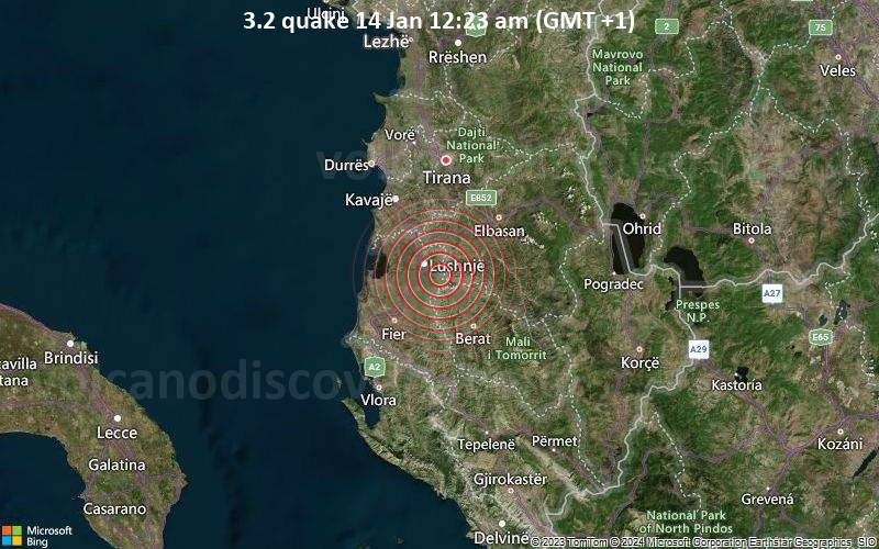
Golem (43.9 km NNW of epicenter) [Map] / Moderate shaking (MMI V) / rattling, vibrating / 5-10 s
Lushnje, Rrethi i Lushnjës, Fier (7.5 km WNW of epicenter) [Map] / Moderate shaking (MMI V)
Tirana (48.1 km N of epicenter) [Map] / Weak shaking (MMI III) / horizontal (sideways) swinging / 5-10 s : Short and horizontal vibration  
Tirana (48.5 km N of epicenter) [Map] / not felt (reported through our app)
Durres, Durrës District (54.5 km NNW of epicenter) [Map] / Light shaking (MMI IV) (reported through our app)
Tirana (46 km N of epicenter) [Map] / Weak shaking (MMI III) / 2-5 s
Kavajë, Tirana (37 km NNW of epicenter) [Map] / Very weak shaking (MMI II) (reported through our app)
Fier (34.3 km SW of epicenter) [Map] / Moderate shaking (MMI V) / horizontal (sideways) swinging / 5-10 s
Tirana (47.3 km N of epicenter) [Map] / Light shaking (MMI IV) (reported through our app)
Samaticë, Bashkia Ura Vajgurore, Berat (8.2 km SSW of epicenter) [Map] / not felt (reported through our app)
Tirana (45.2 km N of epicenter) [Map] / not felt (reported through our app)
Vlorë / Weak shaking (MMI III) / horizontal (sideways) swinging / 5-10 s
Tirana / Weak shaking (MMI III) / rattling, vibrating / 2-5 s : Roof creaked Bed vibrated  
Vlore / Light shaking (MMI IV) / horizontal (sideways) swinging / 15-20 s
Durres / Weak shaking (MMI III) : Bed was moving and there was some building creaking.  
Vlorë / Weak shaking (MMI III) / horizontal (sideways) swinging / 5-10 s
Durres / Weak shaking (MMI III) / horizontal (sideways) swinging
Vlore / Light shaking (MMI IV) / horizontal (sideways) swinging / 2-5 s
Fier / Weak shaking (MMI III) / rattling, vibrating / 10-15 s : A little bit scared, not ready to handle the situation, upset  
Fier / Light shaking (MMI IV) / rattling, vibrating / 5-10 s
Karbunar e madhe / Light shaking (MMI IV) / rattling, vibrating / 2-5 s
Tirana / Light shaking (MMI IV) / horizontal (sideways) swinging / 15-20 s
Fier / Light shaking (MMI IV) / single lateral shake / 1-2 s
Tirana / Weak shaking (MMI III) / horizontal (sideways) swinging / 2-5 s : Weak shaking standing on bed  
Tirana / Weak shaking (MMI III) / horizontal (sideways) swinging / 2-5 s : Sitting on couch, shaking sideways. Plants shaking  
Tirana / Weak shaking (MMI III)
Ohrid, Macedonia / Very weak shaking (MMI II) / rattling, vibrating / 2-5 s
Tirana / Very weak shaking (MMI II) / 5-10 s
Vlore / Light shaking (MMI IV) / horizontal (sideways) swinging / 2-5 s
Tirana / Light shaking (MMI IV)
Tirana / Weak shaking (MMI III) / 2-5 s
Show more

List of cities/places with most reports

PlaceDistance from epicenterAverage reported Shaking IntensityNr. of reports
Tirana, Tirana, Albania
(Pop.: 374,801)
48 km (30 mi)
N of epicenter
III: Weak shaking3
Kavajë, Tirana, Albania
(Pop.: 29,354)
37 km (23 mi)
NW of epicenter
IV: Light shaking2
Fier, Qarku i Fierit, Albania
(Pop.: 56,297)
27 km (17 mi)
SW of epicenter
V: Moderate shaking1
Durres, Durres, Albania
(Pop.: 122,034)
54 km (34 mi)
NW of epicenter
IV: Light shaking1
Lushnje, Qarku i Fierit, Albania
(Pop.: 41,469)
7.8 km (4.9 mi)
NW of epicenter
V: Moderate shaking1
Note: Only reports with latitude/longitude coordinate positions given (11 in total) could be used for statistics.

What is Intensity and the Mercalli Intensity Scale?


The amount of shaking that occurs on the surface due to an earthquake is called the intensity. It is commonly measured on the so-called Modified Mercalli Intensity Scale (MMI) ranging from 1 (not felt) to 10 (extreme shaking), and given in Roman numerals as I,II,...IX, X, and often displayed with color codes ranging from light blue to dark red.
Earthquake intensity depends mainly on the magnitude and depth of the quake as well as the distance from the epicenter: The further away, the less shaking intensity occurs.
Read more about the MMI scale!

Number of reports by intensity

Shaking intensityNumber of reportsMin-Max distance from epicenter (*)Average distance (*)
I: Not felt38.2–48 km (5.1–30 mi)34 km (21 mi)
II: Very weak shaking137–37 km (23–23 mi)37 km (23 mi)
III: Weak shaking246–48 km (29–30 mi)47 km (29 mi)
IV: Light shaking147–47 km (29–29 mi)47 km (29 mi)
V: Moderate shaking37.5–44 km (4.7–27 mi)29 km (18 mi)
Notes
(*) Reports are filtered to exclude those that are likely highly inaccurate or esaggerated.
Only reports with latitude/longitude coordinate positions given (11 in total) could be used for geographic statistics.

Compare Quake Data

Data for the same earthquake as reported by different agencies

The more agencies report about the same quake and post similar data, the more confidence you can have in the data. It takes normally up to a few hours until earthquake parameters are calculated with near-optimum precision.
Mag Depth Time GMT
2024-01-13
Epicenter Agency
3.2 5 km
3.1 mi
23:23:26 Albania SSS (Seismological Survey of Serbia)
2.7 7.9 km
4.9 mi
23:23:28 Albania
9.5 km (5.9 mi) epicenter difference with SSS
EMSC (European-Mediterranean Seismological Centre)
3.0 7.9 km
4.9 mi
23:23:27 Costa Albanese Settentrionale (ALBANIA)
9.5 km (5.9 mi) epicenter difference with SSS
INGV (Istituto Nazionale di Geofisica e Vulcanologia)

Seismograms

Seismic station: Castrocucco, Italy (CUC/MN network) | Distance from quake: 350 km / 218 mi | Show on map | Station Info
Seismic station Castrocucco, Italy: vertical movement plot around time of quake (source: IRIS/BUD)
Seismogram (vertical component) around time of quake. Thin dotted red line indicates time of quake. Seismic waves arrive some time later, depending on distance. Bandpass filter applied: 0.5-10.0 Hz. Source: IRIS Buffer of Uniform Data (BUD) webtool
Show more

Earthquake statistics

Average number of earthquakes

Based on data from the past 54 years and our earthquake archive back to 1900, there are about 583 quakes on average per year in the area near the epicenter of this quake (within 100 km/61 mi):
  • Mag. 6 or higher: 0.06 quakes per year (or 1 quake every 17.9 years)
  • Mag. 5 or higher: 0.63 quakes per year (or 1 quake every 1.6 years)
  • Mag. 4 or higher: 21.4 quakes per year
  • Mag. 3 or higher: 90 quakes per year (or 7.5 quakes per month)
  • Mag. 2 or higher: 494 quakes per year (or 41 quakes per month)
  • Mag. 1 or higher: 582 quakes per year (or 49 quakes per month)
The area where this quake occurred has a high level of seismic activity. It has had at least 7 quakes above magnitude 6 since 1900, which suggests that larger earthquakes of this size occur infrequently, probably on average approximately every 15 to 20 years.

Number of quakes per year

Previous quakes in the same area of this earthquake

Map of earlier quakes in the area of this quake

[smaller] [bigger]

Map to embed or share

Why is there advertising on this site?
Sources: VolcanoDiscovery / VolcanoAdventures and other sources as noted.
Use of material: Most text and images on our websites are owned by us. Re-use is generally not permitted without authorization. Contact us for licensing rights.
Volcanoes & Earthquakes
VolcanoDiscovery Home
Volcanoes | Earthquakes | Photos | Volcano News | App
Adventure & Study Travel
Tours to Volcanoes and Volcanic Areas: walking tours, photo tours, study tours
Tours & Dates | FAQ | About us
Get our newsletter!
Company info
Contact | Legal info | Terms & conditions
Follow us
Follow us on facebook Follow us on Instagram Follow us on Twitter Visit our Youtube channel
EN | DE | EL | ES | FR | IT | RU
VolcanoDiscovery GmbH, Germany, Reg. nr.: HRB 103744, EU Tax Id: DE 297 465 123 owned and created by
Dr. Tom Pfeiffer, volcanologist, volcano photographer, tour organizer member of
IAVCEI
IAVCEI
Vulkanologische Gesellschaft
Volcanological Society
Ecotourism Greece
Ecotourism Greece
RUV insurance
Insured by R+V
VolcanoDiscovery © 2004- All Rights Reserved | Privacy - Cookie Settings
Cookie-free, privacy-friendly web stats