Contact | RSS | EN | DE | EL | ES | FR | IT | RU

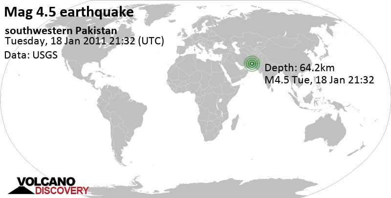
Mag. 4.5 earthquake - southwestern Pakistan on Wednesday, Jan 19, 2011, at 02:32 am (Karachi time)

This quake was likely an aftershock of the 7.2 quake 46 km west of Dalbandin, Balochistan, Pakistan, Jan 19, 2011 01:23 am (Karachi time), which had occurred 1 hour and 9 minutes earlier.

A moderate magnitude 4.5 earthquake hit 48 km (30 mi) away from Dalbandin, Balochistan,  Pakistan, in the early morning of Wednesday, Jan 19, 2011 at 2.32 am local time (Asia/Karachi GMT +5). The quake had a shallow depth of 64 km (40 mi) .
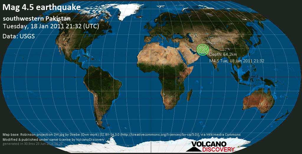
Mag. 4.5 earthquake - southwestern Pakistan on Wednesday, Jan 19, 2011, at 02:32 am (Karachi time) Mag. 4.5 earthquake - southwestern Pakistan on Wednesday, Jan 19, 2011, at 02:32 am (Karachi time)
Moderate magnitude 4.5 earthquake at 64 km depth

Earthquake details

Date & timeJan 18, 2011 21:32:29 UTC
Local time at epicenterWednesday, Jan 19, 2011, at 02:32 am (Asia/Karachi GMT +5)
StatusConfirmed
Magnitude4.5
Depth64 km
Epicenter latitude / longitude28.709°N / 63.956°E Chāgai, Balochistan, Pakistan
Also near: Afghanistan 79 km (49 mi) away
Seismic antipode28.709°S / 116.044°W
Shaking intensityIII Weak shaking near epicenter
Felt0 reports
Primary data sourceUSGS (United States Geological Survey)
Nearest volcanoSultan (121 km / 75 mi)
Estimated seismic energy released3.5 x 1011 joules (98.6 megawatt hours, equivalent to 84.8 tons of TNT) | about seismic energy
[smaller] [bigger]

Nearby places

The closest larger town where the quake might have been felt is Dalbandin, a town with 15,000 inhabitants in Pakistan, in 48 km (30 mi) distance northeast of the epicenter. People likely experienced weak shaking there.
The following table shows some of the places that might have been affected (or not) by the shaking.
Distance Place Max. shaking intensity(*) Region Country
48 km (30 mi)
NE of epicenter
Dalbandin
(pop: 14,600)
III: Weak
Chāgai, Balochistan
143 km (89 mi)
E of epicenter
Kharan
(pop: 30,800)
II: Very weak
Kharan, Balochistan
222 km (138 mi)
NE of epicenter
Nushki
(pop: 27,700)
II: Very weak
Balochistan
259 km (161 mi)
E of epicenter
Kalat
(pop: 26,700)
II: Very weak
Kalāt, Balochistan
273 km (170 mi)
W of epicenter
Khāsh
(pop: 69,600)
II: Very weak
Sistan and Baluchestan
279 km (173 mi)
E of epicenter
Khuzdar
(pop: 141,200)
II: Very weak
Khuzdār, Balochistan
338 km (210 mi)
NE of epicenter
Quetta
(pop: 733,700)
I: Not felt
Balochistan
344 km (214 mi)
NE of epicenter
Caman
(pop: 88,600)
I: Not felt
Qila Abdullāh, Balochistan
351 km (218 mi)
NW of epicenter
Zabol
(pop: 122,000)
I: Not felt
Sistan and Baluchestan
361 km (224 mi)
SE of epicenter
Bela
(pop: 20,100)
I: Not felt
Balochistan
Notes:
(*) Shaking intensity according to the Modified Mercalli Intensity Scale (MMI) and estimated using seismic models.

User-reports for this quake

There are no user reports for this quake yet.

If you felt it, be the first to report it!
User reports estimate the perceived ground shaking intensity according to the MMI (Modified Mercalli Intensity) scale.
There are no user reports for this quake.

Compare Quake Data

Data for the same earthquake as reported by different agencies

The more agencies report about the same quake and post similar data, the more confidence you can have in the data. It takes normally up to a few hours until earthquake parameters are calculated with near-optimum precision.
Mag Depth Time GMT
2011-01-18
Epicenter Agency
4.5 64 km
40 mi
21:32:29 southwestern Pakistan USGS (United States Geological Survey)
4.9 80 km
50 mi
21:32:30 Southwestern Pakistan
4.3 km (2.7 mi) epicenter difference with USGS
EMSC (European-Mediterranean Seismological Centre)

Seismograms

Seismic station: Univ. of Sharjah, Sharjah, United Arab Emirates (UOSS/II network) | Distance from quake: 875 km / 544 mi | Show on map | Station Info
Seismic station Univ. of Sharjah, Sharjah, United Arab Emirates: vertical movement plot around time of quake (source: IRIS/BUD)
Seismogram (vertical component) around time of quake. Thin dotted red line indicates time of quake. Seismic waves arrive some time later, depending on distance. Bandpass filter applied: 0.2-5.0 Hz. Source: IRIS Buffer of Uniform Data (BUD) webtool
Show more

Previous quakes in the same area of this earthquake

Map of earlier quakes in the area of this quake

[smaller] [bigger]

Map to embed or share

Why is there advertising on this site?
Sources: VolcanoDiscovery / VolcanoAdventures and other sources as noted.
Use of material: Most text and images on our websites are owned by us. Re-use is generally not permitted without authorization. Contact us for licensing rights.
Volcanoes & Earthquakes
VolcanoDiscovery Home
Volcanoes | Earthquakes | Photos | Volcano News | App
Adventure & Study Travel
Tours to Volcanoes and Volcanic Areas: walking tours, photo tours, study tours
Tours & Dates | FAQ | About us
Get our newsletter!
Company info
Contact | Legal info | Terms & conditions
Follow us
Follow us on facebook Follow us on Instagram Follow us on Twitter Visit our Youtube channel
EN | DE | EL | ES | FR | IT | RU
VolcanoDiscovery GmbH, Germany, Reg. nr.: HRB 103744, EU Tax Id: DE 297 465 123 owned and created by
Dr. Tom Pfeiffer, volcanologist, volcano photographer, tour organizer member of
IAVCEI
IAVCEI
Vulkanologische Gesellschaft
Volcanological Society
Ecotourism Greece
Ecotourism Greece
RUV insurance
Insured by R+V
VolcanoDiscovery © 2004- All Rights Reserved | Privacy - Cookie Settings
Cookie-free, privacy-friendly web stats