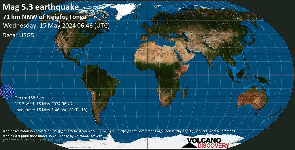
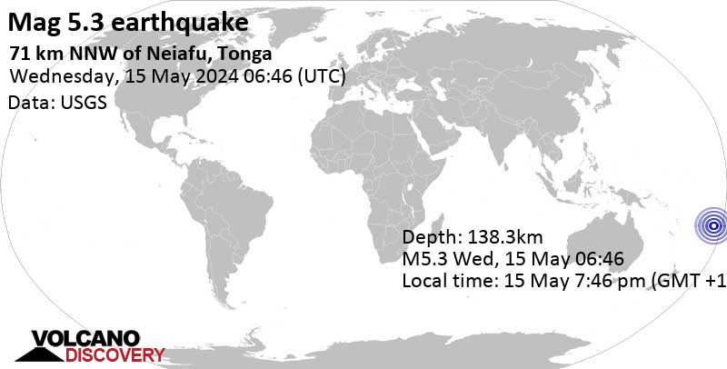
Strong mag. 5.3 Earthquake - 71 km NNW of Neiafu, Tonga, on Wednesday, May 15, 2024, at 07:46 pm (Tongatapu time) -
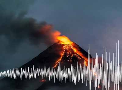
A strong magnitude 5.3 earthquake occurred in the South Pacific Ocean near the coast of Tonga in the late afternoon of Wednesday, May 15, 2024 at 7.46 pm local time (Pacific/Tongatapu GMT +13). The quake had a moderate depth of 138 km (86 mi) and was reported felt by some people near the epicenter.
The German Research Centre for Geosciences (GFZ) reported a magnitude 5.3 quake in Tonga near Neiafu, Vava'u, only 11 minutes ago. The earthquake hit early evening on Wednesday, May 15th, 2024, at 7:46 pm local time at an intermediate depth of 146 km. The exact magnitude, epicenter, and depth of the quake might be revised within the next few hours or minutes as seismologists review data and refine their calculations, or as other agencies issue their report. Based on the preliminary seismic data, the quake should not have caused any significant damage, but was probably felt by many people as light vibration in the area of the epicenter. Weak shaking might have been felt in Neiafu (pop. 4,300) located 64 km from the epicenter. VolcanoDiscovery will automatically update magnitude and depth if these change and follow up if other significant news about the quake become available. If you're in the area, please send us your experience through our reporting mechanism, either online or via our mobile app. This will help us provide more first-hand updates to anyone around the globe who wants to know more about this quake.
Download the Volcanoes & Earthquakes app and get one of the fastest seismic alerts online: Android | iOS
Earthquake details
Date & time
May 15, 2024 06:46:01 UTC -
Local time at epicenter
Wednesday, May 15, 2024, at 07:46 pm (Pacific/Tongatapu GMT +13)
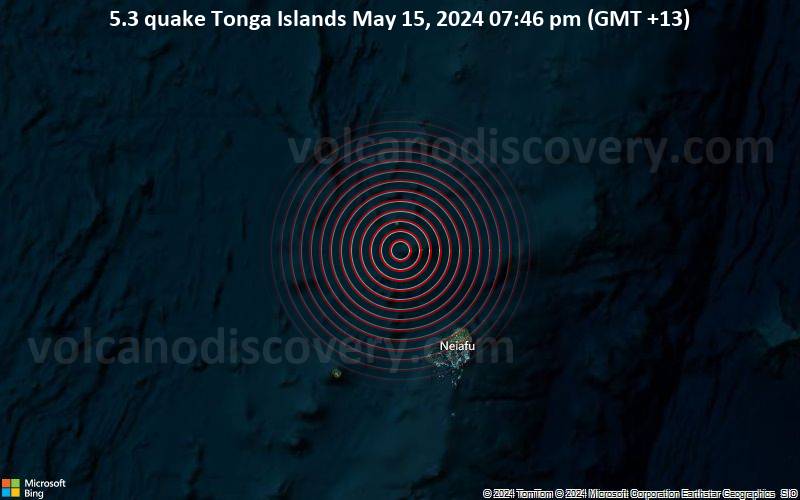
The closest larger town where the quake might have been felt is Neiafu, a town with 4,300 inhabitants in Tonga, in 71 km (44 mi) distance south of the epicenter. People likely experienced weak shaking there. In the capital of Wallis and Futuna, Mata-Utu, 571 km (355 mi) away from the epicenter, the earthquake was probably felt as very weak shaking. The following table shows some of the places that might have been affected (or not) by the shaking.
Notes: (*) Shaking intensity according to the Modified Mercalli Intensity Scale (MMI) and estimated using seismic models.
User-reports for this quake (2)
We received 2 reports for this quake from Tonga. The quake was reported to have been felt in up to approx. 70 km (43 mi) distance, with isolated cases to have felt the quake even 71 km (44 mi) away.
Most reports came from Neiafu, a town with 4,300 inhabitants in Vava'u in 71 km (44 mi) distance south of the epicenter, Tonga. Further below is a list of places where most people reported this quake.
Contribute: Leave a comment if you find a particular report interesting or want to add to it. Flag as inappropriate. Mark as helpful or interesting. Send your own user report!
Translate
Neiafu, Vava‘u (68.9 km SSE of epicenter) [Map] / Weak shaking (MMI III) / horizontal (sideways) swinging / very short
Neiafu (71.2 km SSE of epicenter) [Map] / Very weak shaking (MMI II) / rattling, vibrating / 1-2 s
Note: Only reports with latitude/longitude coordinate positions given (2 in total) could be used for statistics.
What is Intensity and the Mercalli Intensity Scale?
The amount of shaking that occurs on the surface due to an earthquake is called the intensity. It is commonly measured on the so-called Modified Mercalli Intensity Scale (MMI) ranging from 1 (not felt) to 10 (extreme shaking), and given in Roman numerals as I,II,...IX, X, and often displayed with color codes ranging from light blue to dark red. Earthquake intensity depends mainly on the magnitude and depth of the quake as well as the distance from the epicenter: The further away, the less shaking intensity occurs. Read more about the MMI scale!
Number of reports by intensity
Shaking intensity
Number of reports
Min-Max distance from epicenter (*)
Average distance (*)
II: Very weak shaking
1
71–71 km (44–44 mi)
71 km (44 mi)
III: Weak shaking
1
69–69 km (43–43 mi)
69 km (43 mi)
Notes (*) Reports are filtered to exclude those that are likely highly inaccurate or esaggerated. Only reports with latitude/longitude coordinate positions given (2 in total) could be used for geographic statistics.
Compare Quake Data
Data for the same earthquake as reported by different agencies
The more agencies report about the same quake and post similar data, the more confidence you can have in the data. It takes normally up to a few hours until earthquake parameters are calculated with near-optimum precision.
Notes: (*) A depth given as 10 km often means that the the depth of the quake could not determined with sufficient accuracy.
Seismograms
Seismic station: Afiamalu, Samoa (AFI/IU network) | Distance from quake: 523 km / 325 mi | Show on map | Station Info
Seismogram (vertical component) around time of quake. Thin dotted red line indicates time of quake. Seismic waves arrive some time later, depending on distance. Bandpass filter applied: 0.02-5.0 Hz. Source: IRIS Buffer of Uniform Data (BUD) webtool
Seismic station: Monasavu, Fiji (MSVF/II network) | Distance from quake: 826 km / 513 mi | Show on map | Station Info
Seismogram (vertical component) around time of quake. Thin dotted red line indicates time of quake. Seismic waves arrive some time later, depending on distance. Bandpass filter applied: 0.02-5.0 Hz. Source: IRIS Buffer of Uniform Data (BUD) webtool
Seismic station: Funafuti, Tuvalu (FUNA/IU network) | Distance from quake: 1278 km / 794 mi | Show on map | Station Info
Seismogram (vertical component) around time of quake. Thin dotted red line indicates time of quake. Seismic waves arrive some time later, depending on distance. Bandpass filter applied: 0.02-5.0 Hz. Source: IRIS Buffer of Uniform Data (BUD) webtool
No aftershocks have been recorded so far. When aftershocks are detected, we will update this section.
What are aftershocks?
Larger earthquakes (above magnitude 5 or so) such as this one are usually followed by smaller ones known as aftershocks that occur in the same area during the days, weeks, months or even years after the main shock.
[More info]
Aftershocks are typically at least one order of magnitude smaller than the main shock. Their size and frequency decreases with time.
What about this quake?
Based on its magnitude, the fault that was active during the quake likely ruptured beneath a surface of approx. 20 km2 (=8 sqare miles) as a first-order estimate. The length of the rupture zone thus was probably around 8 km (5 mi).
[More info]
Aftershocks for this quake can be expected to occur during the days and few weeks following the quake at or near the same fault, at distances of up to approx. two times the length of the rupture zone, or in this case 15 km (10 mi). The often broadly linear arrangement of aftershock epicenters encompasses the rupture zone of the main shock (see map below).
Recorded aftershocks, latest first (0 quake)
Date and Time GMT
Mag Depth
Distance
Region
Details
May 15, 2024 07:46 pm (Tongatapu) 5 weeks ago - felt
5.3
138 km
0 km - This quake
South Pacific Ocean, 71 km N of Neiafu, Vava'u, Tonga
Based on data from the past 14 years and our earthquake archive back to 1900, there are about 23.3 quakes on average per year in the area near the epicenter of this quake (within 100 km/61 mi):
Mag. 6 or higher: 0.17 quakes per year (or 1 quake every 5.9 years)
Mag. 5 or higher: 5.9 quakes per year
Mag. 4 or higher: 22.6 quakes per year
Mag. 3 or higher: 22.7 quakes per year
Mag. 2 or higher: 22.7 quakes per year
The area where this quake occurred has a very high level of seismic activity. It has had at least 21 quakes above magnitude 6 since 1900, which suggests that larger earthquakes of this size occur infrequently, probably on average approximately every 5 to 10 years.
Number of quakes per year
Previous quakes in the same area of this earthquake
Earthquakes near volcanoes Earthquakes often precede volcanic eruptions. Find out where the latest earthquakes in the vicinity of volcanoes have occurred.
Krakatau volcano photos Hundreds of photos from active Krakatau volcano in the Sunda Strait, Indonesia. Most of them taken during our various expeditions to this fascinating volcano.
Kamchatka photos A growing list of photo galleries taking during our expeditions in this fantastic part of the world, full of volcanoes, unspoiled nature and colors.
We truly love working to bring you the latest volcano and earthquake data from around the world. Maintaining our website and our free apps does require, however, considerable time and resources.
We need financing to increase hard- and software capacity as well as support our editor team. We're aiming to achieve uninterrupted service wherever an earthquake or volcano eruption unfolds, and your donations can make it happen! Every donation will be highly appreciated. If you find the information useful and would like to support our team in integrating further features, write great content, and in upgrading our soft- and hardware, please make a donation (PayPal or Online credit card payment).
Planned features:
Improved multilanguage support
Tsunami alerts
Faster responsiveness
Thanks to your past donations, these features have been added recently:
Design upgrade
Detailed quake stats
Additional seismic data sources
Download and Upgrade the Volcanoes & Earthquakes app to get one of the fastest seismic and volcano alerts online: Android | IOS


 27.2°C (81 F), humidity: 87%, wind: 11 m/s (21 kts) from E