= spaces available= guaranteed= few spaces left= booked out
Revealing the Beauty of Volcanic Activity through Satellite Imagery
Guest post by VolcanoDiscovery news editor Martin Kelko
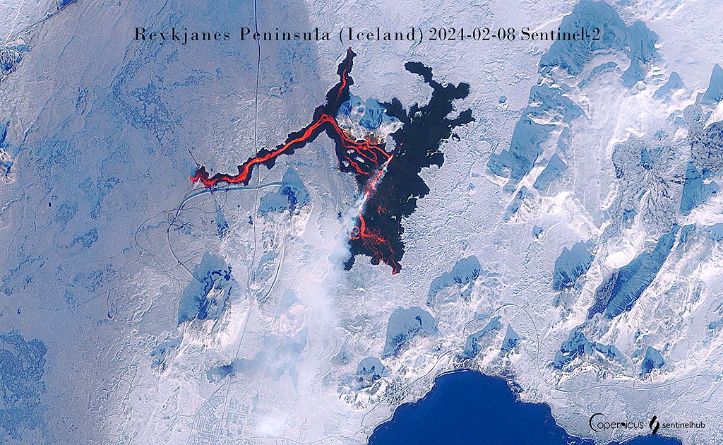
The latest lava flow eruption on Iceland's Reykjanes Peninsula (image: Sentinel-2)
As a volcanologist working as a volcano co-guide and news editor for VolcanoDiscovery for the past four years, I find monitoring volcanic activity through satellites to be among the most fundamental sources to keep and manage up-to-date volcanic events as they occur worldwide. The use of remote sensing has prompted me to delve into the principles of remote sensing, programming, and modern applications.
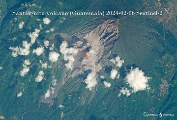
The active lava dome of Santiaguito volcano (Guatemala) continues to grow and glowing lava blocks detach from its flanks (image: Sentinel-2)
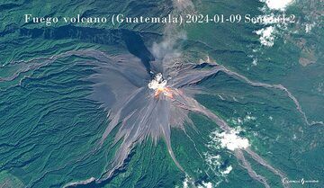
Powerful explosion at Fuego showered summit with glowing lava bombs and formed incandescent avalanches (image: Sentinel-2)
Approximately a year ago, I began exploring various integrated evalscript values on EO Browser, a platform that has become a fundamental source for monitoring volcanic events. Back then, I only used predefined volcano themes with zero experience with digital art.
The Sentinel's comprehensive education workflow webpage became a valuable resource, offering webinars, tutorials, user guides, and a collection of useful custom scripts. Inspired by the satellite imagery processing skills of Pierre Markuse and Iban Ameztoy, I ventured into image processing, primarily focusing on Sentinel-2 and occasionally Sentinel-3 combinations, emphasizing thermal anomalies of volcanoes with natural colour visualizations. Even though there are plenty of combinations, I like this compound by far the most. To enhance satellite images, I employ QGIS for georeferencing and raster graphics editors for aesthetic improvements.
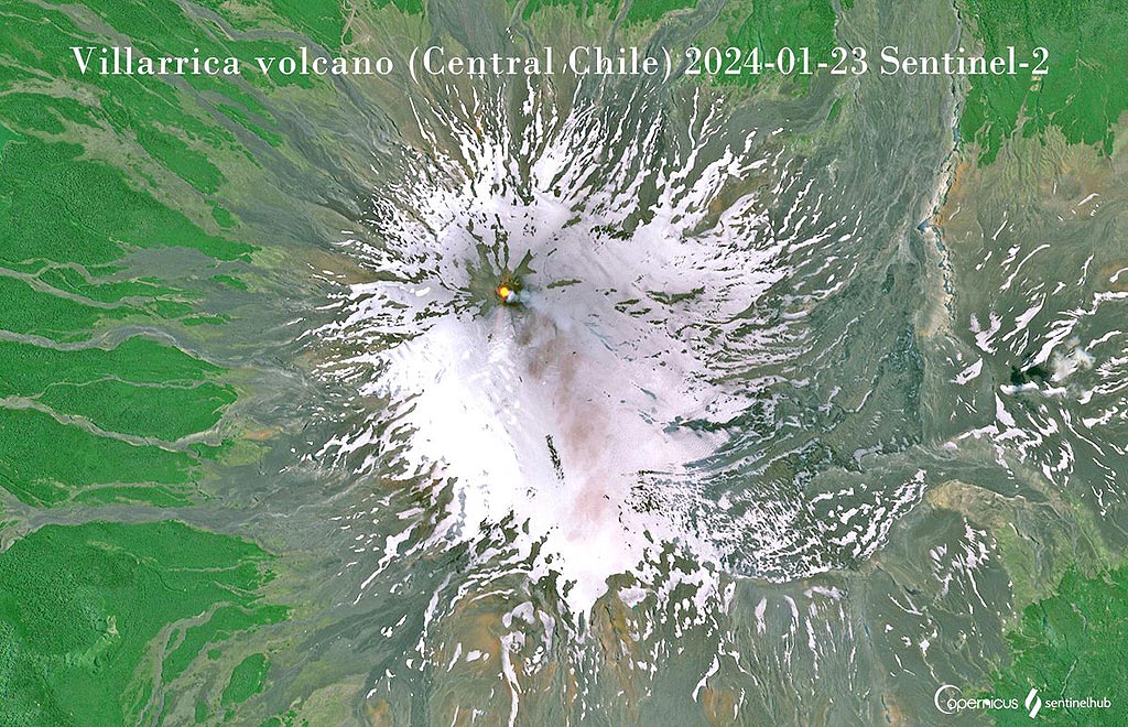
Summit lava pond at Villarrica remains active (image: Sentinel-2)
Over time, I expanded my repertoire to include synthetic-aperture (SAR) radar animations and datasets from Sentinel-1. From a volcanological point of view, I find SAR animations powerful since SAR can penetrate through darkness, clouds, and rain and is highly capable of detecting lava flow development, erosion resulting from eruptive activity, etc.
Beyond this, I have delved into creating optical visualizations and 3D animations, showcasing the versatility of satellite data.
The EO Browser's user-friendly interface, coupled with abundant data sources and diverse predefined views, has made it an indispensable tool. I find myself visiting the platform frequently, captivated by its ability to provide a visually stunning and unique perspective of Earth's landscapes.
In conclusion, EO Browser by Sinergise stands out as a remarkable tool that brings the marvels of Earth's landscapes to our fingertips, harnessing the capabilities of satellite imagery for a comprehensive understanding of our planet.
The animated gif compiled from Sentinel-1 radar images shows the evolution of Anak Krakatau volcano since late 2018 when most of its summit cone collapsed, triggering a deadly tsunami. In the months and years after this event, continued activity has been filling the initial crater lake and is now in the process of growing a new cone in its place.
The active Santiaguito lava dome (Guatemala) has been in a state of steady eruption for many years. Viscous lava is rising and accumulating in the active dome, as well as forming slow-moving lava flows. This time-lapse from satellite imagery shows the emplacement of a new lava flow on the SW side, reaching several km length over an interval of approx. 3 years compressed into 6 seconds.
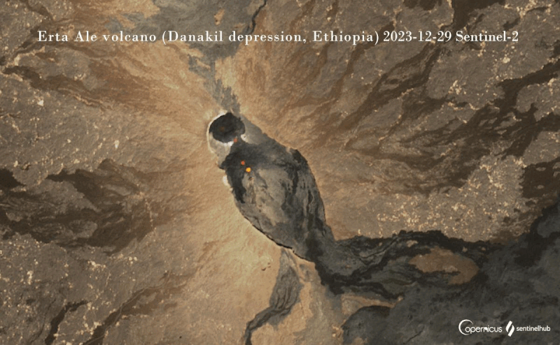
Frequent lava overflows from active vents in the Erta Ale caldera during the past years
Monitoring Volcanoes from Space: the use of satellite imagery and data
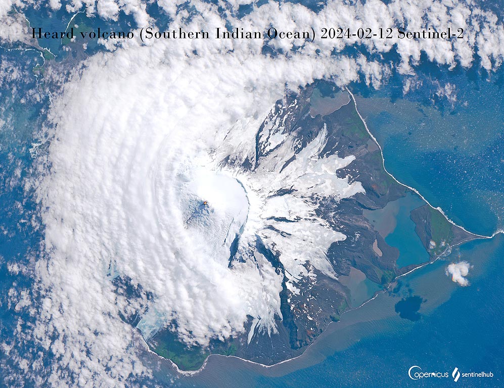
Summit lava lake and a lava flow visible on Heard volcano (image: Sentinel-2)
Monitoring volcanic activity is a crucial aspect of disaster management and risk assessment, given its profound impact on both the environment and human populations. In recent years, technological advancements, particularly in satellite imagery, have revolutionized the way scientists can study and monitor volcanoes.
Dallol hot springs One of the most bizarre landscapes on earth: Dallol is a vast and very active hydrothermal field creating a colorful array of hot springs, small geysers, salt towers, colorful lakes and ponds in the middle of the deepest part of the Danakil desert and the Karum salt lake.
Volcano Expeditions Witnessing a volcanic eruption from close is an unforgettable experience. We offer a wide variety of tours and expeditions to active volcanoes worldwide.
We truly love working to bring you the latest volcano and earthquake data from around the world. Maintaining our website and our free apps does require, however, considerable time and resources.
We need financing to increase hard- and software capacity as well as support our editor team. We're aiming to achieve uninterrupted service wherever an earthquake or volcano eruption unfolds, and your donations can make it happen! Every donation will be highly appreciated. If you find the information useful and would like to support our team in integrating further features, write great content, and in upgrading our soft- and hardware, please make a donation (PayPal or Online credit card payment).
Planned features:
Improved multilanguage support
Tsunami alerts
Faster responsiveness
Thanks to your past donations, these features have been added recently:
Design upgrade
Detailed quake stats
Additional seismic data sources
Download and Upgrade the Volcanoes & Earthquakes app to get one of the fastest seismic and volcano alerts online: Android | IOS